

Palmist Ankur is a leading mundane astrologer based in Norway. He has numerous successful earthquake predictions to his credit, including the Kamchatka mega quake, the December 8 Japan M7.6 quake, and the highly damaging Bangladesh, Bohol (Philippines), Afghanistan, Mandalay and Shigatse earthquakes in the recent past. He has also accurately predicted several tech outages, disasters and accidents (Brown University and Bondi Beach mass shootings, Hong Kong, Dhaka and Ōita fires, UPS plane crash in Kentucky, Amur Oblast and Bangladesh plane crashes, etc.), as well as weather events. All his astrological services can be viewed here.
Please read this sticky post to understand better the advantages and shortcomings of my earthquake prediction techniques as of now.
I am continuously working, whenever I have time, to refine my method to a greater precision. Hence, please do support me in this endeavour by upgrading to paid subscriptions or making a donation, if you can afford it: this would enable me to dedicate more of my time to further research. An ever higher precision method to predict disasters would be good for all humanity, including yourself.
If you want me to provide earthquake predictions’ probability for a specific location during a specific period in the future, it is a paid service. Please see here (limited scope; nominal charges) or here (larger scope, including advice on suitable timings to start the journey, especially useful when one has to travel even though weather or earthquake prognostics aren’t great; higher charges).
To see a non-exhaustive list of successful Weather & Earthquake Watch predictions in the past, click here (for 2024) or here (for 2025). I update that list only sporadically for lack of time, given that each day will bring several successful predictions. Much more frequent updates regarding successful predictions can be found on my social media.
STANDING WARNING by me since a long time:
“Overall, there could be several huge or damaging earthquakes and landslides as well as water-related events (tsunami, severe typhoons, floodings, etc.) in the world during the period from late July 2025 to April 2026.”
Other points to remember:
(1) Overall, this period could be marked by strong earthquakes and major accidents (especially air and water accidents). There could also be major incidents affecting children or the young, students, travellers/commuters and mediapersons during this period. High winds and strong precipitation to mark several places, and there could even be a tornado in some places. There could also be communication or transmission troubles (such as cyber hacks, network breaches, widespread power outages, etc.) during this period. Death of some major writers/journalists and artists (especially actors, painters and singers/musicians) could happen in this period.
(2) For areas not far from the Prime Meridian (0° longitude), prediction lines may be activated from the evening of 25 December 2025 itself.
(3) I had tweeted this on 14 December:
"Dec 29-Jan 2: uptick in earthquake activity & transportation accidents; death of prominent writer(s) or media figure(s) likely; incidents of terror possible; incidents targeting students, children or places of education, or places of culture, entertainment, leisure and tourist interest, likely; prominent incidents involving casualties possible in India, Israel, England or the USA or targeting Hindu or Jewish communities."
(4) I had tweeted this on 21 December:
"Dec 26 around 3 PM UTC (give or take a few hours) may produce a major malefic accident, something like earthquake, major accident or fire, or strongly violent accident."
And this:
"Another critical time, for accident, quakes or incidents affecting the young, travellers, communication or media, is around Dec 30 5 AM UTC (give or take a few hours)."
And now below is the next set of predictions, for the Western Hemisphere. Predictions for the Eastern Hemisphere (i.e., Part I) were already published earlier, here.
Astroseismological predictions for the period from 26 December 2025 to 6 January 2026 (Part II, Western Hemisphere):
This post won’t be edited once published. This post is being published on 25 December 2025 UTC 2:30. If any typos are discovered later, they will be left as is. If any more serious errors are discovered or something missing is found later, they would be published in a separate Errata/Addendum post.
Earthquakes are predicted near the following imaginary lines (within 250 km, but mostly much closer). You may extrapolate all lines further at both their ends (especially for accidents). Ignore red coordinate symbols unless I ask you to pay attention to it: they usually don’t mean anything special other than they are also a point on the respective line. If a high magnitude is predicted for a particular region, then that high magnitude applies to all prediction lines when passing through that region, even if I have not mentioned any magnitude or mentioned a lower magnitude for the other lines.
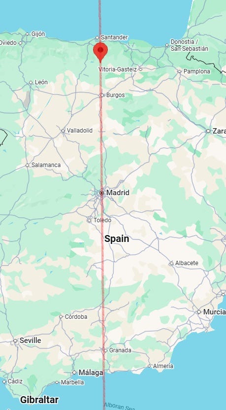
- Straight line running through 43°00′N, 3°44′W (near Santelices, Castile and León, Spain). The line passes through Spain’s capital, Madrid, but probability is higher in the Bay of Biscay area. The quake may not cross M4.5, and may rather be between M3.5 and M4.2.
- Line between 43°00′N, 8°28′W (near Torre, Oleiros, A Coruña, Spain) and 36°00′N, 4°04′W (off Málaga, Andalusia, Spain).
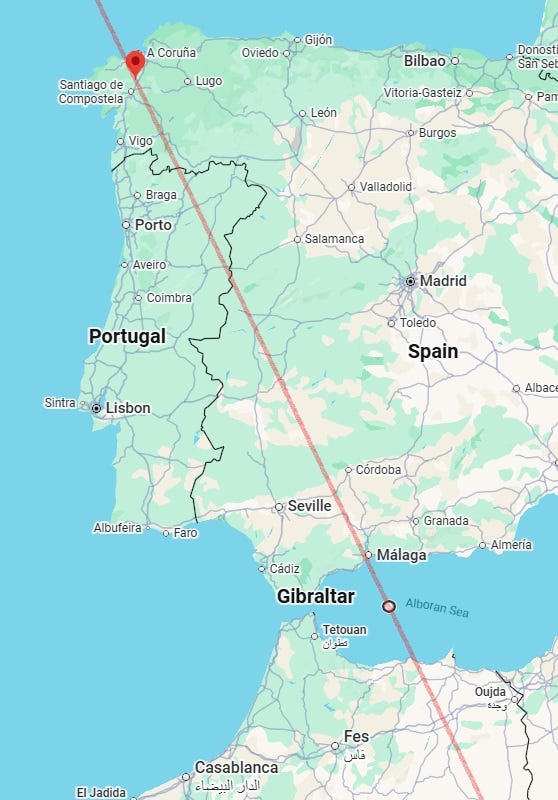
The Eastern Hemisphere section of this line was published earlier in Part I.
- Line between 41°36′N, 8°20′W (near Braga, Portugal) and 36°00′N, 4°52′W (off Marbella, Málaga, Spain).
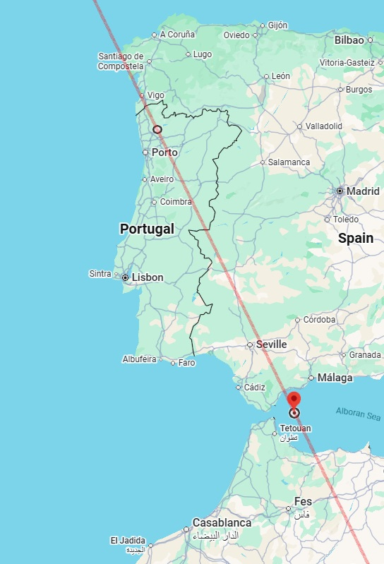
The Eastern Hemisphere section of this line was published earlier in Part I.
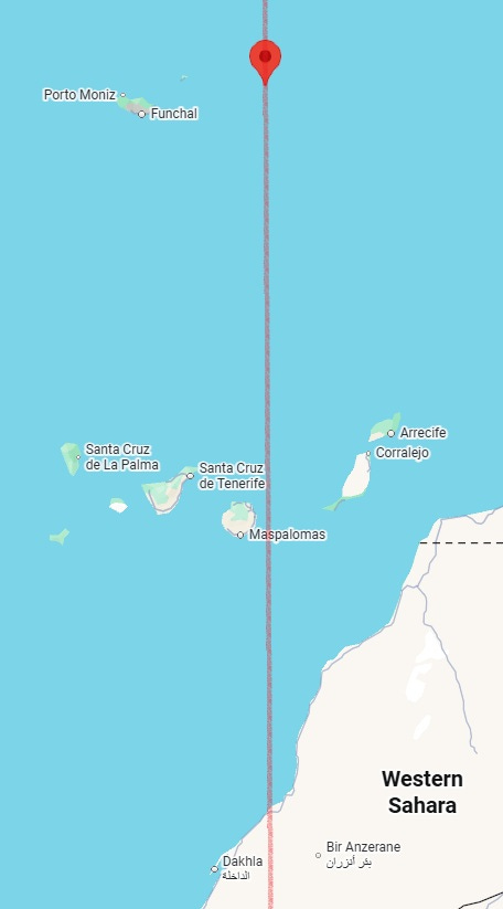
- Straight line running through 33°00′N, 15°15′W (east off Vila Baleira, Madeira, Portugal). M5.5+ earthquake could occur near this line, especially in the Madeira-Canary Islands area near this line (the wider area of the red coordinate symbol here). Accidents, violence and other malefic incidents also possible near this line.
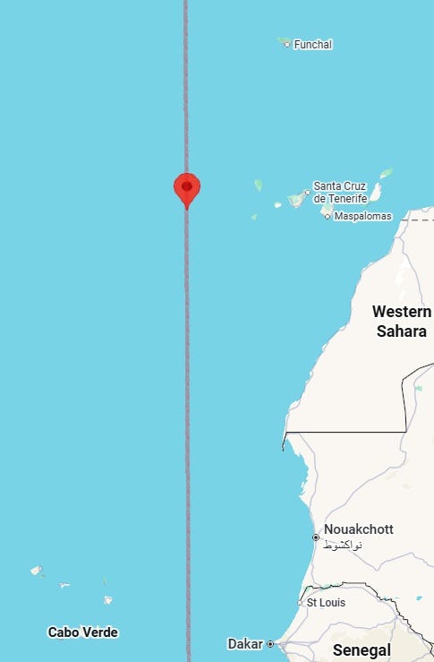
- Straight line running through 28°00′N, 20°13′W (west off Canary Islands, Spain). Strong rains also possible near some parts of this line.
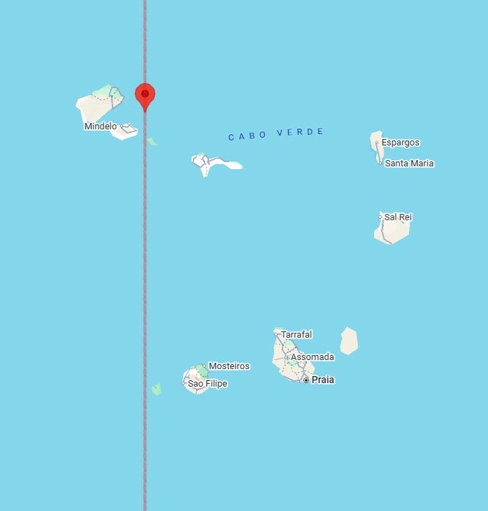
- Straight line running through 17°00′N, 24°48′W (off Calhau, São Vicente, Cabo Verde). M5.0+ earthquake could occur near this line. Accidents or other malefic incidents, in addition to or instead of, earthquakes possible near this line.
- Line between 28°00′N, 26°46′W (a point in the North Atlantic) and 17°00′N, 21°09′W (east off Cabo Verde). Storms or heavy precipitation could also occur near some parts of this line.
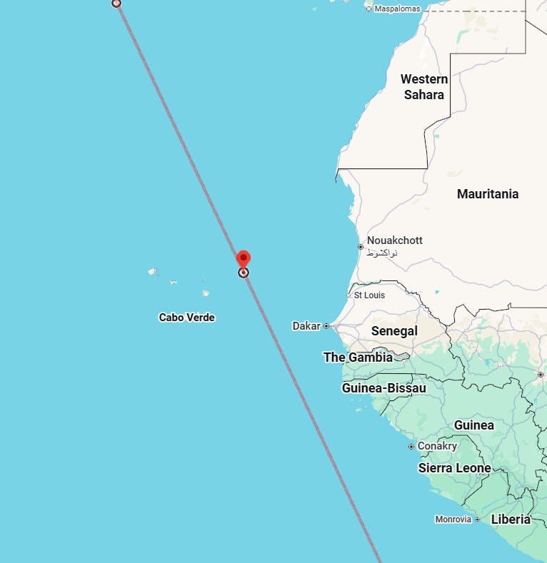
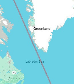
- Line between 17°00′N, 23°06′W (northwest off Sal Island, Cabo Verde) and 8°00′S, 12°05′W (east off Cat Hill, Ascension, Saint Helena, Ascension and Tristan da Cunha). Accidents, storms or incidents affecting travellers or the young also possible near this line. Any vehicles in the vicinity of this line ought to be very careful.
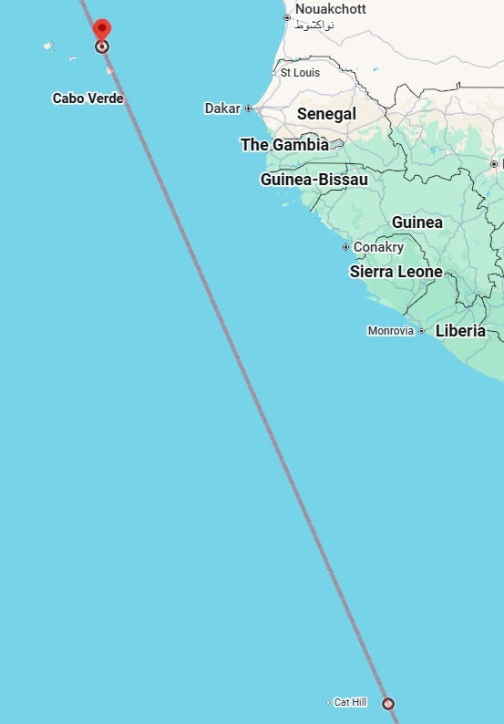
When extended north, the line will go close by the western coastline of Greenland:
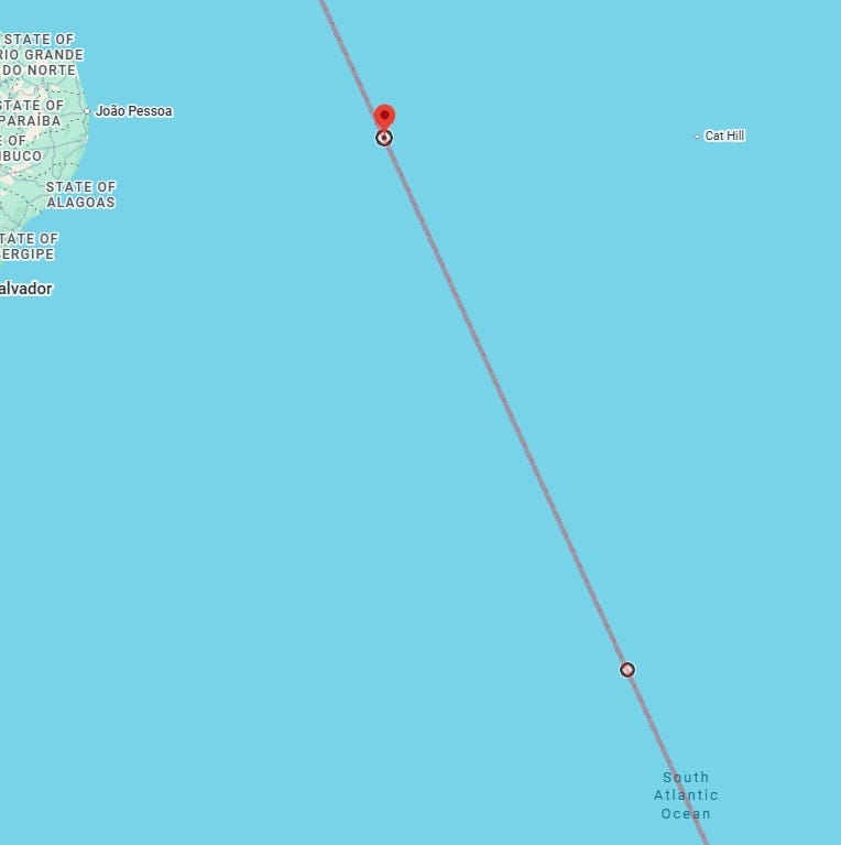
- Line between 8°00′S, 24°54′ (off Brazil) and 25°00′S, 16°45′W (a point in the South Atlantic). Heavy precipitation could also occur near some parts of this line.
- Straight line running through 10°00′S, 27°41′W (off Maceió, Alagoas, Brazil). Strong rains and other malefic incidents also possible near this line.
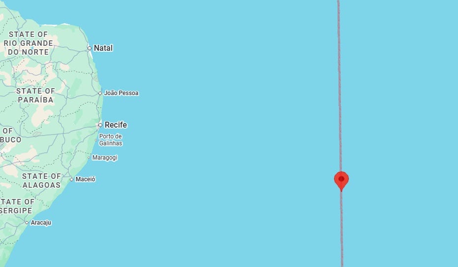
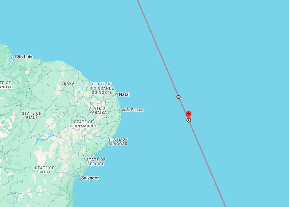
- Line between 6°00′S, 29°46′W (off Natal, Rio Grande do Norte, Brazil) and 8°00′S, 28°53′W (off Recife, Pernambuco, Brazil). Earthquakes are not common in the pictured area, but M4.0+ earthquake, or even an M5.0+ quake, could occur in this area during this period. Other malefic incidents, major accidents or high winds also possible.
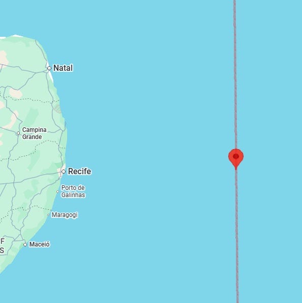
- Straight line running through 8°00′S, 31°03′W (off Recife, Pernambuco, Brazil). Accidents and high winds also possible near some parts on this line.
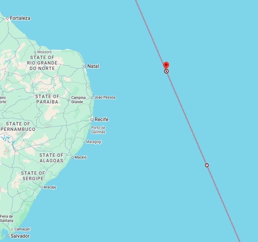
- Line between 6°00′S, 31°41′W (off Natal, Rio Grande do Norte, Brazil) and 10°00′S, 29°56′W (off Maceió, Alagoas, Brazil). Accidents or violence also possible near this line.
- Straight line running through 5°30′S, 37°26′W (near Governador Dix-Sept Rosado, Rio Grande do Norte, Brazil). Accidents or other malefic incidents, in addition to or instead of, earthquakes possible near this line.
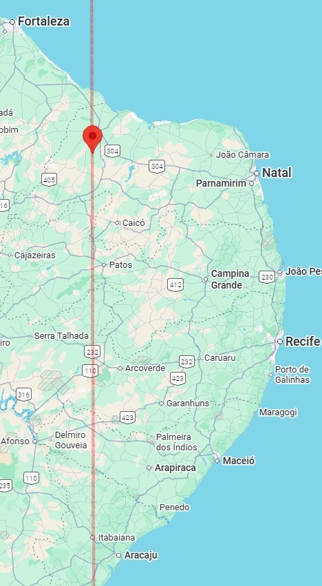
Several of the preceding lines as well as this line (and some of the following lines) will cross into Greenland region: I have not looked at Greenland area with attention because of lack of time.
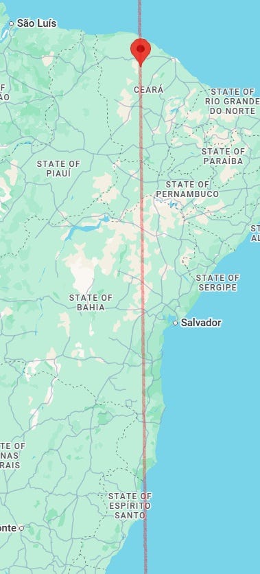
- Straight line running through 4°00′S, 39°44′W (near Boa Vista do Caxitoré, Irauçuba, Ceará, Brazil). Accidents or other malefic incidents, in addition to or instead of, earthquakes possible near this line.
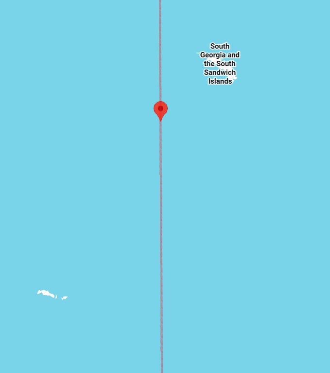
M5.5+ quake possible in the region of this line that is near the South Sandwich Islands:
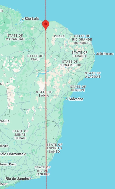
- Straight line running through 4°00′S, 41°15′W (near São João da Fronteira, Piauí, Brazil).
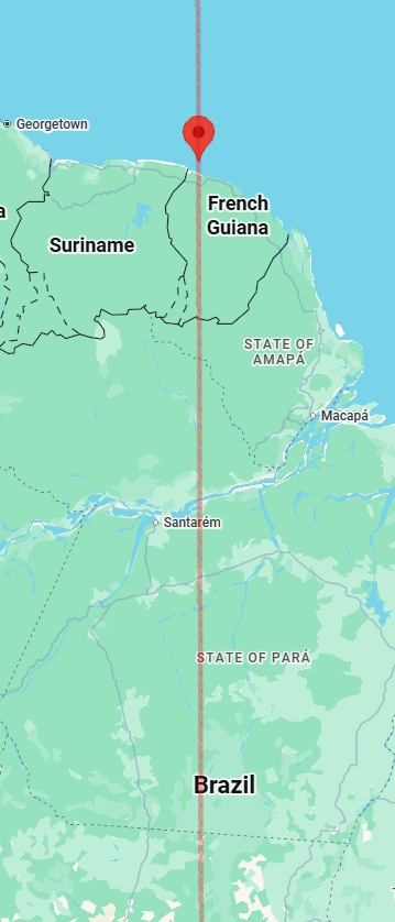
- Straight line running through 6°00′N, 53°43′W (off Mana, Arrondissement of St.-Laurent-du-Maroni, French Guiana). M5.0+ earthquake possible near this line.
- Line between 10°00′N, 61°46′W (off Chatham, Siparia Regional Corporation, Trinidad and Tobago) and 21°34′S, 50°00′W (Avanhandava, São Paulo, Brazil). M5.0+ earthquake likely near this line. At the southern end of this line (roughly the Goiás-São Paulo-Paraná area of Brazil), even an M5.5+ earthquake could happen, or very strongly violent incident/accident could take place. Weather, too, could be very bad in some areas near this line. Aviation accidents, shootings, falling from heights (including off horses!) and communication troubles could happen near this area. At the northern end of the pictured line (roughly the Grenada-Trinidad and Tobago-Venezuela area), accidents or troubles to ruling authorities could occur besides the potential earthquakes.
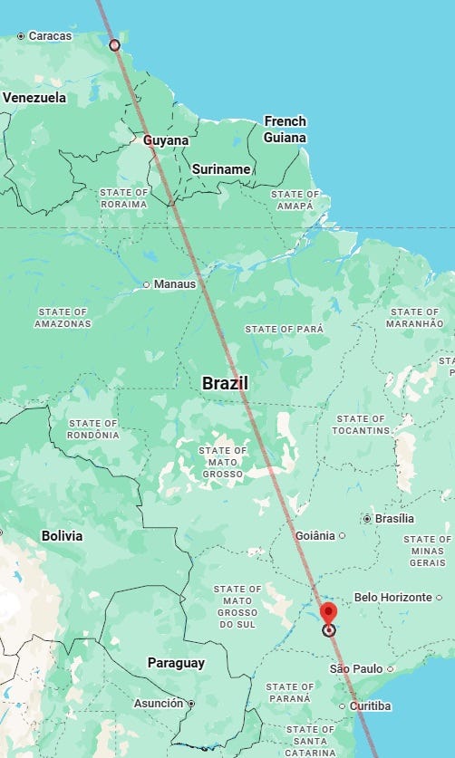
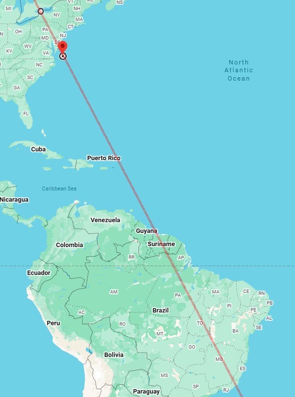
When extended north, the line will go through the Puerto Rico-Virgin Islands-Anguilla region (in which region accidents or incidents of violence or drowning also possible), before crossing the Atlantic and hitting Northeast USA. In this region, the same line can be described thus: between 45°00′N, 79°10′W (near Bracebridge, Ontario, Canada) and 38°00′N, 74°25′W (off Ocean City, Maryland, USA). Strong incidents of violence, explosions and shootings (especially at heights), events bringing disgrace and noteworthy incidents of snakebites or involving other reptiles likely in this section of the line (and even in the Carolinas, which are a bit away from the line, as long as these non-earthquake types of events are concerned) besides the potential earthquakes.
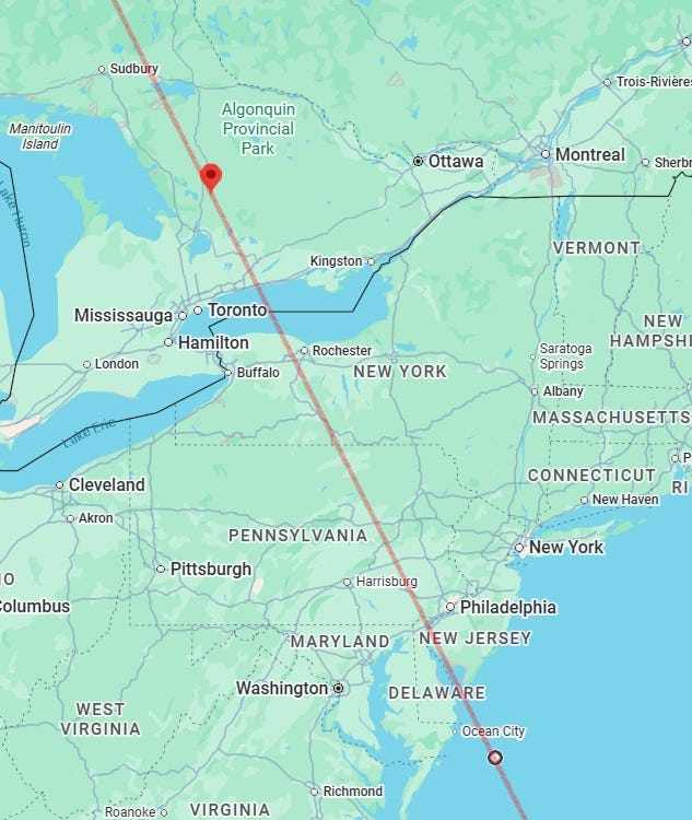
- Line between 43°30′N, 78°33′W (off Barker, New York, USA) and 37°00′N, 74°22′W (off Virginia Beach, Virginia, USA), which is a line close to the previous line. M5.0+ earthquake likely near this line. Again, same description of possible incidents in this section as for the Bracebridge-Ocean City section on earlier line. Note that the line passes close by Washington DC, the capital of the USA.
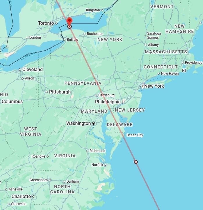
The line should be extrapolated further south, and same descriptions would apply as for the previous line when it crosses the Virgin Islands-Anguilla region and then onwards Venezuela and Brazil regions. I leave it to the reader to make the extrapolation; a wider overview of the line is given here:
- Straight line running through 5°00′S, 79°05′W (near Namballe, Cajamarca, Peru).
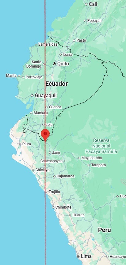
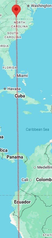
When extended north, the line would go through Panama and Cuba and go between Florida (USA) and the Bahamas:
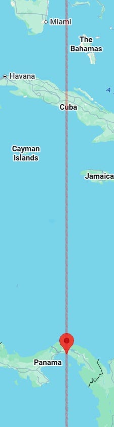
This line, however, appears more or less innocuous until it hits the area around North Carolina (USA), when the line becomes very malefic.
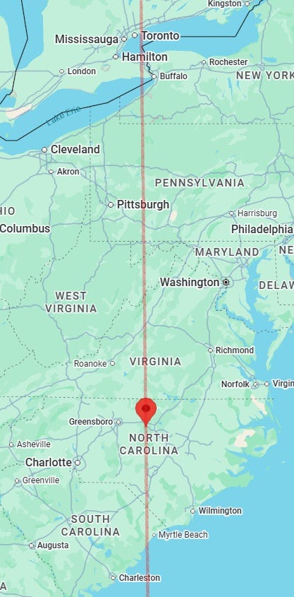
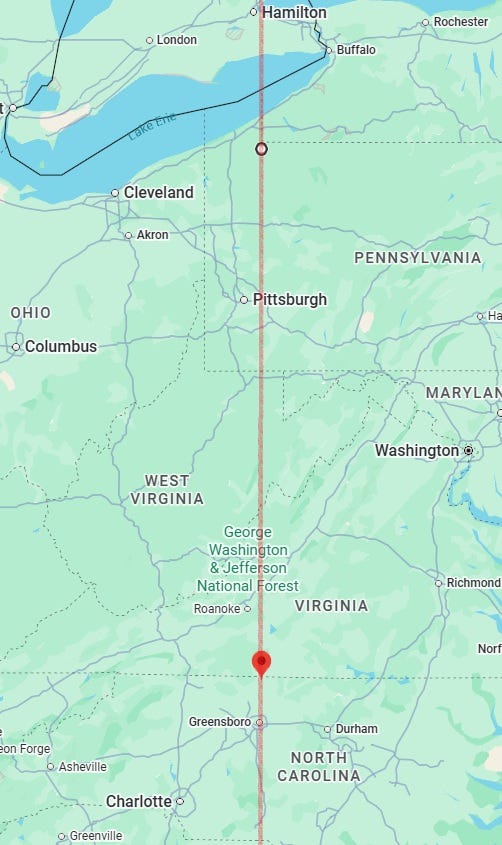
Strong violence affecting a number of people, incidents of poisoning, accidents in mines and other underground facilities, other accidents and bad weather could happen around this area, especially in the following pictured area:
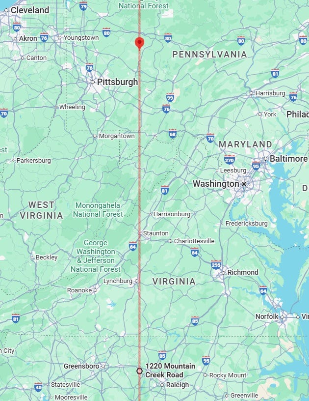
- Straight line passing through 37°00′N, 79°46′W (near Glade Hill, Virginia, USA), which will go on to cross Cuba, Panama, Ecuador and Peru. M5.0+ earthquake possible near this line.
Again, as far as violent incidents are concerned, the most malefic part of the line is pictured thus:
The same description applies to this area of the line as for the previous line’s pictured area around Penn State-North Carolina (USA).
- Straight line running through 17°00′N, 90°19′W (near La Pava Nueva, Petén, Guatemala).
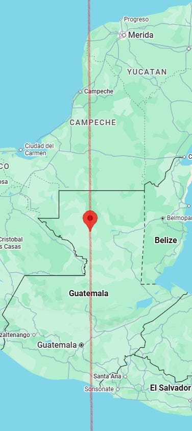
For lack of time, I haven’t looked closely at this line or the next line.
- Line between 19°30′N, 96°46′W (south of Almolonga, Veracruz, Mexico) and 17°11′N, 96°24′W (near Las Vigas, Oaxaca, Mexico).
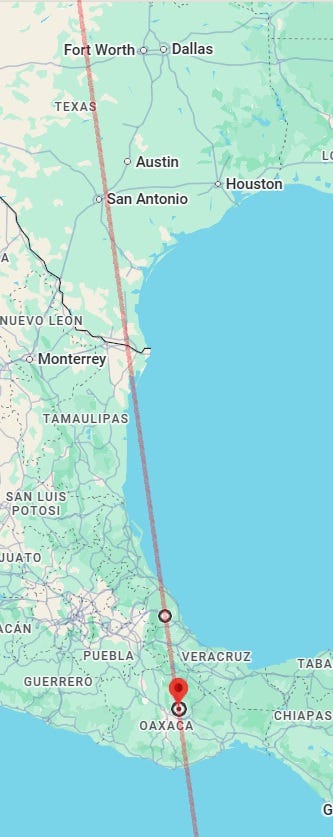
- Straight line running through 20°00′N, 103°39′W (near Tepec, Jalisco, Mexico). Violence or accidents could also take place near this line.
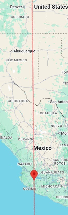
For lack of time, I haven’t looked at which sections of the line are vulnerable for which type of incidents.
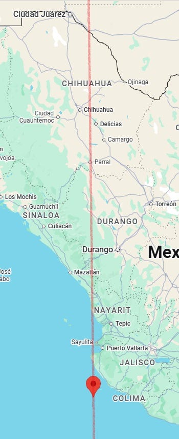
- Straight line running through 19°00′N, 105°33′W (south off La Cruz de Loreto, Jalisco, Mexico). Accidents or incidents affecting students, the young, travellers or mediapersons also possible near this line. The Durango-Nayarit-Jalisco-Colima region of Mexico on the line is more malefic, and other malefic incidents could also occur in this section.
- Line between 38°00′N, 108°12′W (near Norwood, Colorado, USA) and 24°00′N, 106°56′W (near Caimanes II, Sinaloa, Mexico). M5.5+ earthquake possible near this line. Strong violence and other malefic incidents also possible near this line or the next line.
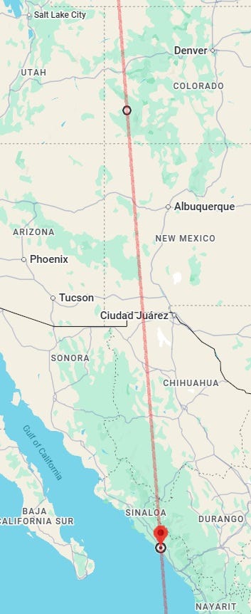
The Denver-Albuquerque (USA) section of this line, roughly speaking, is more malefic, but the entire line is malefic.
- Line between 37°00′N, 111°27′W (north of Page, Arizona, USA) and 28°00′N, 111°05′W (near Rio Azul San Carlos, Sonora, Mexico). M5.0+ earthquake possible near this line. Strong violence and other malefic incidents also possible near this line or the previous line. Some areas near this line could also see a sharp spell of precipitation.
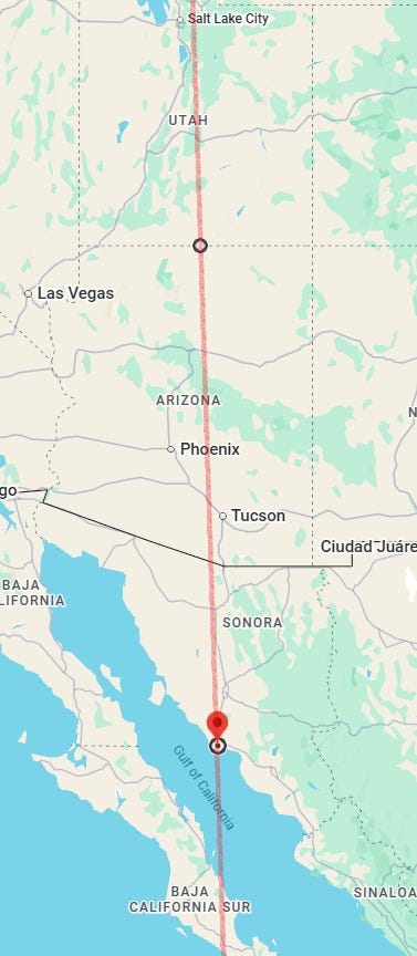
- Line between 34°00′N, 114°33′W (near Vidal, California, USA) and 27°18′N, 114°37′W (south off Puerto Nuevo, Baja California Sur, Mexico). M5.0+ earthquake could occur near this line or the next line. Accidents or other malefic incidents, in addition to or instead of, earthquakes possible near this line. Strong storms, dangers to travellers, incidents of poisoning and dangers to bovine animals (or involving them) also possible near this line or the next line.
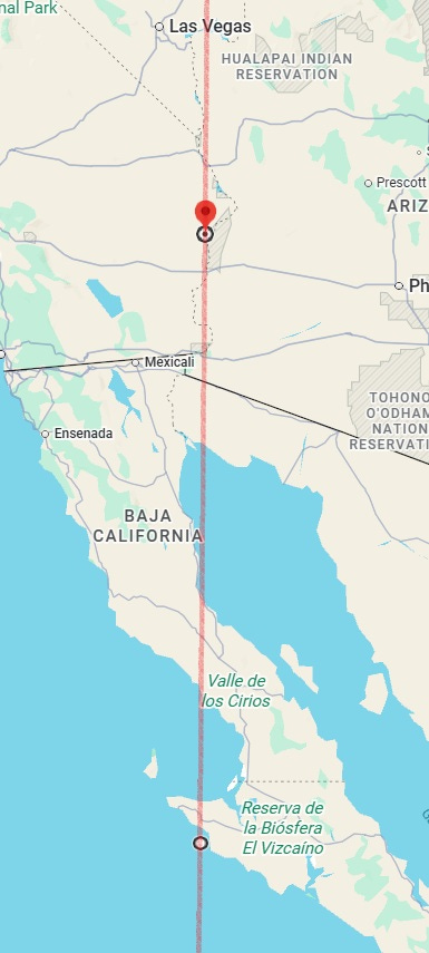
The line can be further extended north to 47°00′N, 114°25′W (near Alberton, Montana, USA), and beyond, passing close by Calgary (Alberta, Canada):
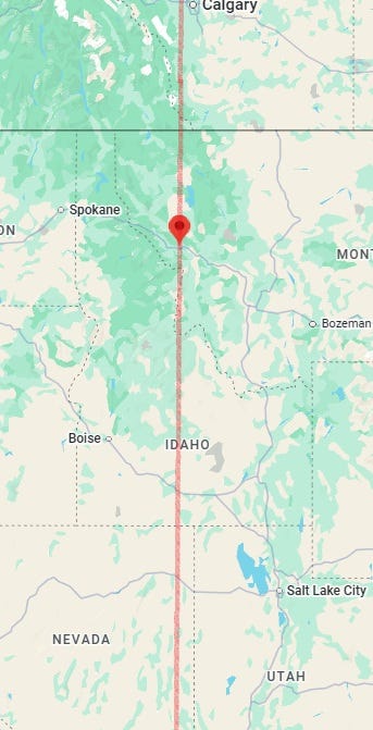
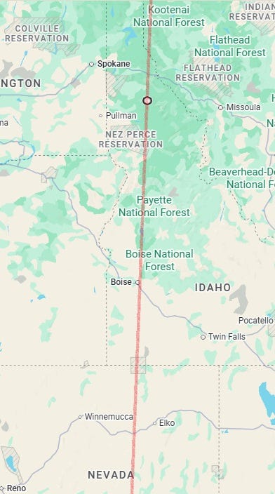
- Line between 37°12′N, 116°28′W (northwest of Amargosa Valley, Nevada, USA) and 32°12′N, 116°40′W (near San José de la Zorra, Baja California, Mexico). M5.0+ earthquake could occur near this line or the previous line. Strong storms, dangers to travellers, incidents of poisoning and dangers to bovine animals (or involving them) also possible near this line or the previous line.
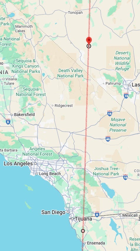
Here is the line seen further extended north to 47°00′N, 115°57′W (south of Hoyt, Idaho, USA), and beyond:
- Line between 37°12′N, 118°43′W (near Aspendell, California, USA) and 34°00′N, 118°59′W (off Thousand Oaks, California, USA). M5.5+ earthquake could occur near this line or the next line. Strong violence and strongly malefic incidents, too, could occur near this line, which passes close by the major urban metropolis of Los Angeles, among other places.
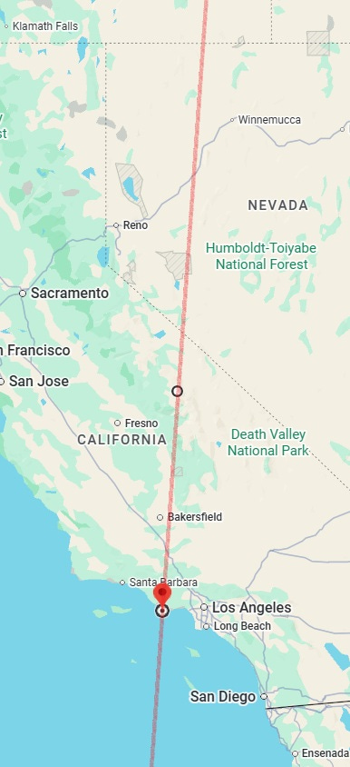
- Straight line running through 37°12′N, 122°21′W (near Pescadero, California, USA). M5.5+ earthquake could occur near this line or the previous line.
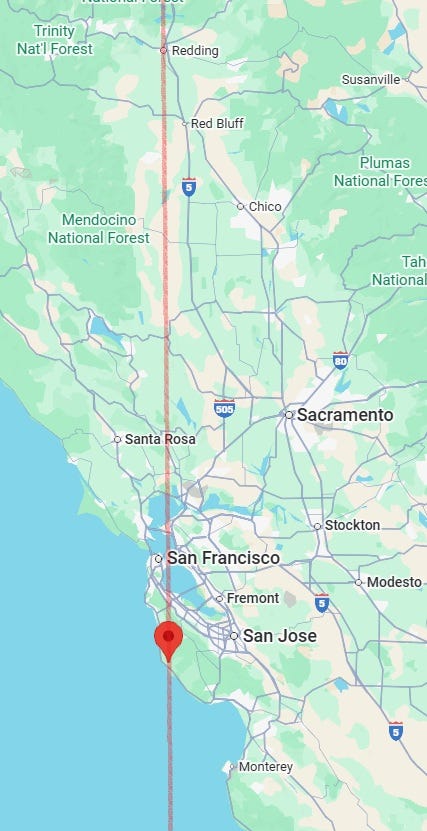
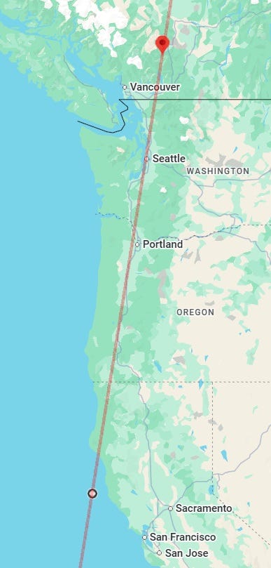
This line, it must be noted, passes close by the major urban areas of western USA and Canada such as San Francisco, Portland, Seattle and Vancouver, among other places. The wider area around San Francisco (California, USA) is the most malefic on this line for incidents such as earthquakes or big fires or other potential mass calamities during this period.
- Line between 49°15′N, 120°42′W (northeast of Manning Park, British Columbia, Canada) and 38°00′N, 122°54′W (off Inverness, California, USA). Accidents or other malefic incidents, in addition to or instead of, earthquakes possible near this line.
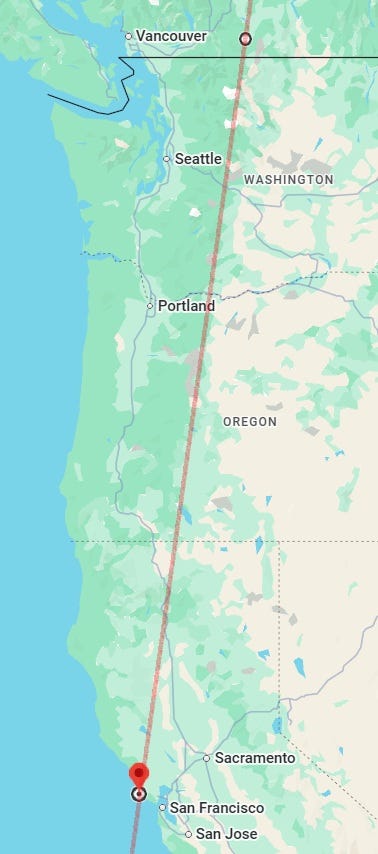
- Straight line running through 39°00′N, 124°15′W (off Manchester, California, USA).
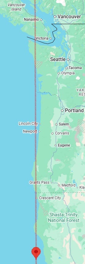
- Line between 50°00′N, 121°40′W (south of Skihist Mountain, British Columbia, Canada) and 39°00′N, 124°16′W (off Manchester, California, USA). Accidents or other malefic incidents, in addition to or instead of, earthquakes possible near this line.
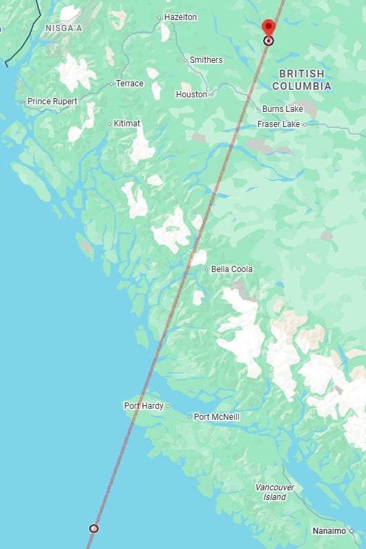
- Line between 55°00′N, 125°33′W (near Leo Creek, British Columbia, Canada) and 49°12′N, 128°56′W (off Vancouver Island, British Columbia, Canada). Accidents or other malefic incidents, in addition to or instead of, earthquakes possible near this line.
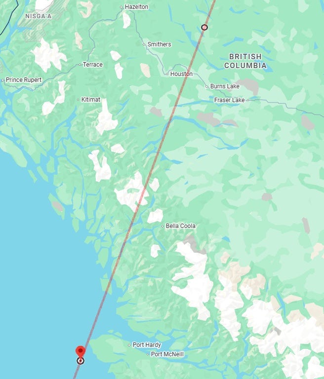
- Line between 55°00′N, 125°49′W (near Granisle, British Columbia, Canada) and 50°30′N, 128°35′W (off Cox Island, British Columbia, Canada).
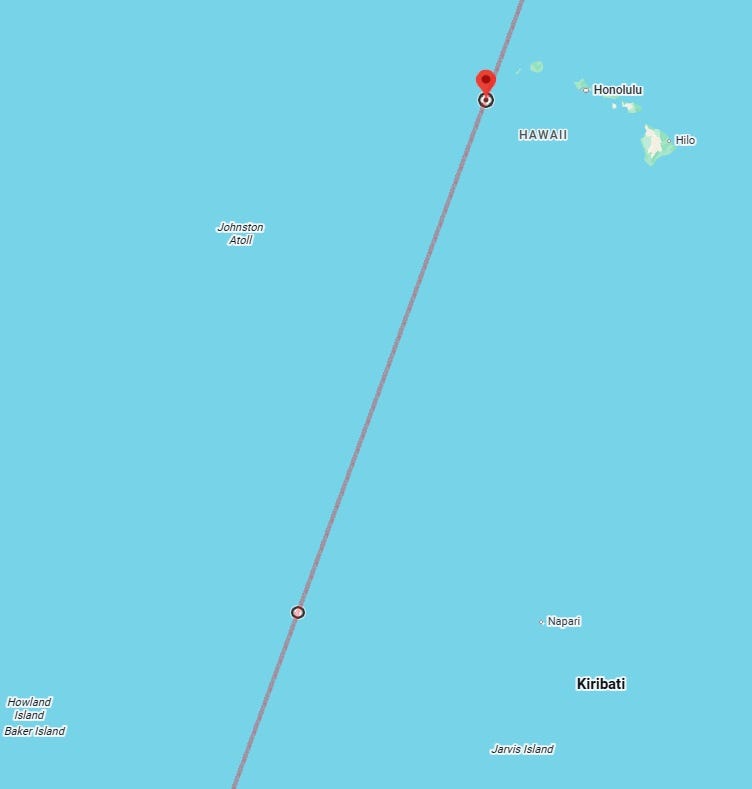
- Line between 21°00′N, 161°15′W (southwest of Puuwai, Hawaii, USA) and 4°15′N, 167°34′W (west of Onouea Village, Line Islands, Kiribati). Take a 300 km margin on the left-hand side of this line instead of the usual 250 km. Accidents (especially of planes), violent incidents, heavy rains and danger from reptiles also possible near this line during this period.
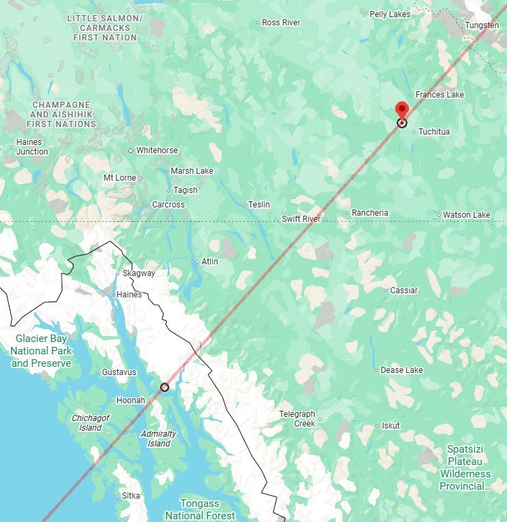
- Line between 61°00′N, 129°28′W (northwest of Tuchitua, Yukon, Canada) and 58°15′N, 134°21′W (near Juneau, Alaska, USA). Take a 270 km margin, instead of the usual 250 km margin, on the right-hand/bottom side of the line.
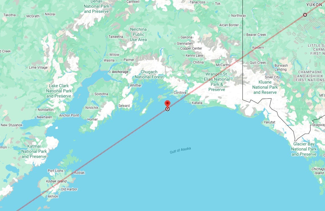
- Line between 63°00′N, 136°49′W (southwest of Summit Roadhouse, Yukon, Canada) and 60°00′N, 146°02′W (off Whitshed, Alaska, USA).
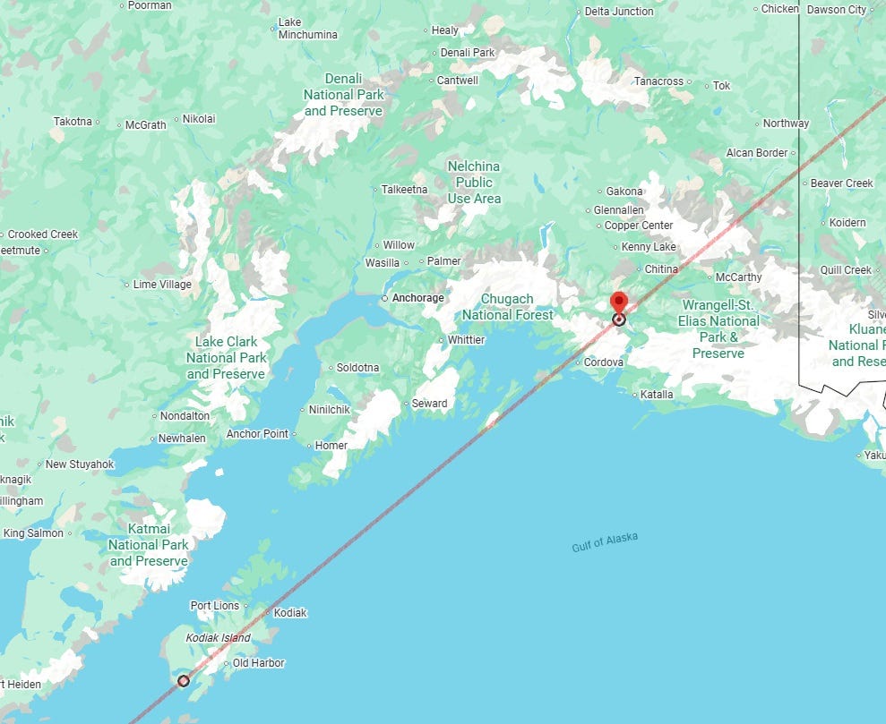
- Line between 61°00′N, 144°52′W (east of Wortmanns, Alaska, USA) and 57°00′N, 154°13′W (near Akhiok, Alaska, USA). M5.0+ earthquake could occur near this line. High winds, storms and accidents also possible near this line.
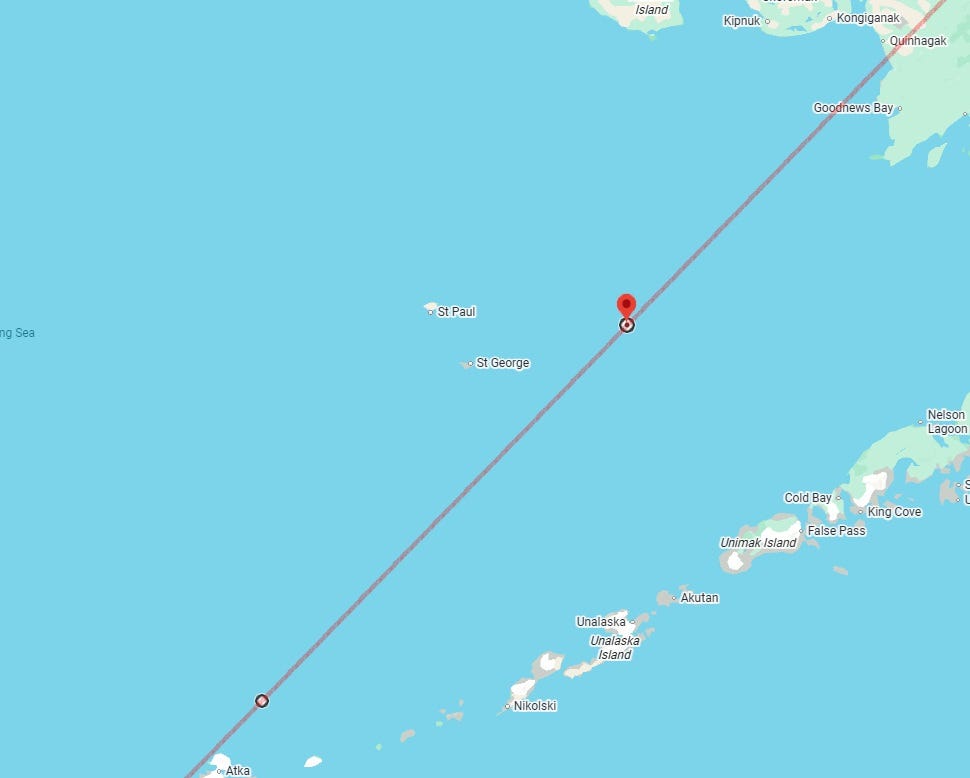
- Line between 57°00′N, 166°39′W (north off Unalaska, Alaska, USA) and 53°00′N, 173°24′W (north off Amlia Island, Alaska, USA). Strong precipitation and/or colder than usual temperatures could also take place near some parts of this line during this period.
- Straight line running through 53°00′N, 173°34′W (north off Amlia Island, Alaska, USA). The Samoa section of this line (when extended south) was shown in Part I.
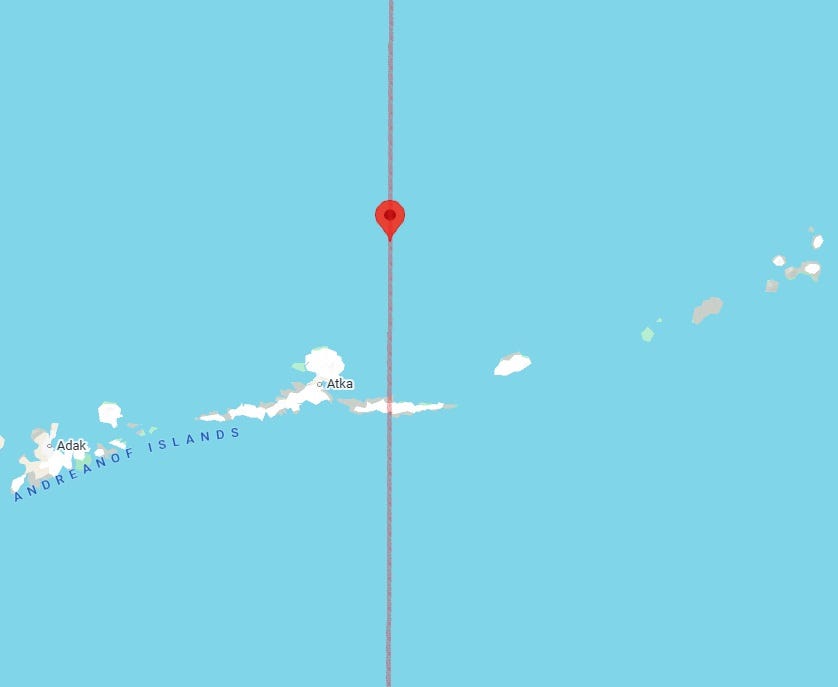
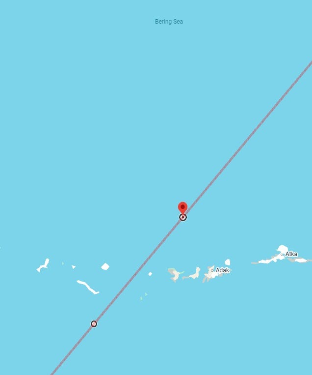
- Line between 53°00′N, 177°40′W (north off Tanaga Island, Alaska, USA) and 50°42′N, 179°14′E (south off Amchitka Island, Alaska, USA). M5.5+ earthquake possible near this line.
Part I, with predictions for the Eastern Hemisphere, for the period of 25 December 2025 to 5 January 2026, was published here, earlier.
Note 1: Owing to lack of time, I am unable to look at every single prediction line in detail. I am publishing only those which look more prominent to me. It is possible that it may lead me to miss publishing some lines near which a strong enough earthquake may take place, but I can only do my best with the time constraints possible. However, wherever a line is given, an earthquake or some other incident that can or does lead to fall of structures is highly likely to happen near it, unless weak probability is already noted.
Note 2: Sometimes, earthquake indications on the chart may be rather about other forms of earth disturbances such as volcanic activity, rockfall, avalanche, mudflow, landslide or ground subsidence. They could also be about “non-natural” forms of falls of structures: for example, the collapse of a bridge, an industrial accident in which a big piece of equipment falls down, a plane crash, or a building or mine collapse. Astrologically, they are all one category. So when I say earthquake, the complete category is meant. Please always bear this in mind.
Note 3: If a big earthquake has happened in a place, aftershocks may continue for days, weeks and even months. I predict the big (the first) earthquake, not always the aftershocks (unless they are also seen prominently on the charts, as does happen sometimes).
Disclaimer: The predictions or interpretations provided on this website or in this newsletter for any weather or earthquake or for anything else are for entertainment purpose only. Nothing is guaranteed to happen. Services offered by Palmist Ankur or any content published by Palmist Ankur are NOT a recommendation or solicitation to buy or sell any securities, bonds or any other financial instruments. While the information that Palmist Ankur provides you is with aims to serve as a guide, it does not replace professional advice. By subscribing to the content of this website or purchasing any other type of service, you fully agree and understand this and waive Palmist Ankur off any responsibility and liability from this event and its outcome.
"- Line between 37°12′N, 118°43′W (near Aspendell, California, USA) and 34°00′N, 118°59′W (off Thousand Oaks, California, USA). M5.5+ earthquake could occur near this line or the next line. Strong violence and strongly malefic incidents, too, could occur near this line, which passes close by the major urban metropolis of Los Angeles, among other places."
This area is already in danger. https://www.cnn.com/2025/12/23/weather/california-storm-flooding-rain-holidays-climate